Monday, July 08, 2024

The Butterfly Nebula: NGC 6302 in Scorpius | European Southern Observatory

The Butterfly Nebula: NGC 6302 in Scorpius | European Southern Observatory

The Bug Nebula: NGC 6302 | Danish 1.54-meter telescope
The Bug Nebula: NGC 6302 close-up | Very Large Telescope
The Bug Nebula: NGC 6302 Wide-field view Digitized Sky Survey 2 (ground-based image)

The Butterfly Nebula, NGC 6302, is one of the brightest and most extreme planetary nebulae known. It is located about 4,000 light-years away, towards the Scorpius constellation (the Scorpion). The nebula is the swansong of a dying solar-like star lying at its center. At about 250,000 degrees Celsius and smothered in a blanket of hailstones, the star itself has never been observed as it is surrounded by a dense disc of gas and dust, opaque to light. This dense disc may be the origin of the hourglass structure of the nebula.

Towards the end of their life, massive stars can expand to giant dimensions. They shed most of the hydrogen in their outer layers as a strong "stellar wind", before they contract towards a final compact stage as "white dwarfs".

After this ejection process, the star remains thousands of times brighter and also much hotter than the Sun during a few thousand years. Its strong ultraviolet radiation has the effect of ionizing the previously ejected gas, which then shines before it disperses into interstellar space. The resulting nebulae (traditionally referred to as Planetary Nebulae , because of their resemblance to a planet in a small telescope) often exhibit very complex morphologies.

The Butterfly Nebula belongs to the class of bipolar nebulae, as this picture clearly illustrates. A dark, dusty and disc-like structure—seen edge-on in this image—obscures the central star from our view. However, its strong radiation escapes perpendicular to the disk and heats and illuminates the material deposited there by the stellar wind.

The origin of the dark disk may be due to the central star being a member of a double star system. This has been shown to be the case in other bipolar nebulae, where contrary to the Butterfly Nebula, there is a direct view towards the star.


Image 1 Credit: ESO / IDA / Danish 1.5 m/R. Gendler, A. Hornstrup and J.-E. Ovaldsen

Image 2 Credit: European Southern Observatory

Image 3 Credit: NASA, ESA, Digitized Sky Survey 2

Image Dates: December 3, 2009 / May 27, 1998 / June 18, 2020


#NASA #ESO #ESA #Astronomy #Space #Science #Hubble #BipolarNebulae #ButterflyNebula #BugNebula #NGC6302 #PlanetaryNebula #Scorpius #Constellation #MilkyWayGalaxy #Cosmos #Universe #DanishTelescope #VLT #DSS2 #Chile #UnitedStates #Europe #STEM #Education

Spiral Galaxy NGC 3810 & Supernova SN2022zut in Leo | Hubble

Spiral Galaxy NGC 3810 & Supernova SN2022zut in Leo | Hubble

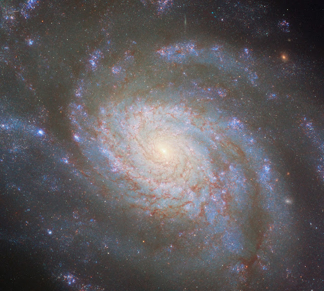
Spiral Galaxy NGC 3810
Spiral Galaxy NGC 3810 & location of Supernova SN2022zut

Measuring the distance to truly remote objects like galaxies, quasars and galaxy clusters is a crucial task in astrophysics, particularly when it comes to studying the early Universe. However, it is a difficult one. Only in the case of a few nearby objects like the Sun, planets and nearby stars can we measure their distances directly. Beyond that, indirect methods need to be used. One of the most important is by examining Type Ia supernovae. This is where the NASA/European Space Agency Hubble Space Telescope comes in.

Distance: 50 million light years

NGC 3810, the galaxy featured in this image, was the host of a Type Ia supernova in 2022. In early 2023 Hubble focused on this and a number of other galaxies to closely examine recent Type Ia supernovae. This kind of supernova results from a white dwarf exploding, and they all have a very consistent brightness. It allows them to be used to measure distances. We know how bright a Type Ia supernova should be, so we can tell how far away it must be from how dim it appears. One uncertainty in this method is that intergalactic dust in between Earth and a supernova blocks a portion of its light. 

How much of the reduction in light is caused by distance, and how much by dust? With the help of Hubble, there is a clever workaround. We can take images of the same Type Ia supernovae in ultraviolet light, almost completely blocked by dust, and in infrared light that passes through dust almost unaffected. By carefully noting how much light comes through at each wavelength, the relationship between supernova brightness and distance can be calibrated to account for dust. Hubble can observe these wavelengths of light in great detail with the same instrument. This makes it the perfect tool for this experiment, and indeed, the data is used to make this beautiful image of NGC 3810. You can see 2022 supernova as a point of light just below the galactic nucleus and in the annotated image.

There are many ways to measure cosmic distances; because Type Ia supernovae are so bright, they are one of the most useful and accurate tools, when they are identified. Many other methods must be used as well, either as an independent check against other distance measurements or to measure at much closer or farther distances. One such method that also works for galaxies is comparing their rotation speed to their brightness; based on that method, NGC 3810 is found to be 50 million light-years from Earth.

Image Description: A spiral galaxy seen almost face-on. Large spiral arms whirl out from its center, filling the scene. They glow faintly blue from the stars within. There are small bright patches of blue and pink marking areas of star formation. They are overlaid with thin filaments of dark reddish dust that block light. The galaxy’s center shines brightly white.


Image Credit: ESA/Hubble & NASA, D. Sand, R. J. Foley

Release Date: July 8, 2024


#NASA #ESA #Astronomy #Space #Hubble #Galaxies #Galaxy #NGC3810 #SpiralGalaxy #Supernovae #Supernova #TypeIASupernova #WhiteDwarfStar #Leo #Constellation #Cosmos #Universe #Astrophysics #HST #SpaceTelescopes #GSFC #STScI #UnitedStates #Europe #STEM #Education

Sunday, July 07, 2024

Annual Arctic Sea Ice Minimum Area (1979-2022) | NASA Earth Observatory

Annual Arctic Sea Ice Minimum Area (1979-2022) | NASA Earth Observatory

Satellite-based passive microwave images of the sea ice have provided a reliable tool for continuously monitoring changes in the Arctic ice since 1979. Every summer the Arctic ice cap melts down to what scientists call its "minimum" before colder weather begins to cause ice cover to increase. This graph displays the area of the minimum sea ice coverage each year from 1979 through 2022. In 2022, the Arctic minimum sea ice covered an area of 4.16 million square kilometers (1.6 million square miles). 

This visualization shows the expanse of the annual minimum Arctic sea ice for each year from 1979 through 2022 as derived from passive microwave data.


Video Credit: NASA Scientific Visualization Studio

Visualizations: Trent L. Schindler

Duration: 46 seconds

Release Date: July 1, 2024


#NASA #Space #Satellites #Science #Planet #Earth #PolarIce #SeaIce #Arctic #IceSurfaceArea #GlobalCO2Emissions #ClimateChange #GlobalHeating #Climate #Environment #GreenhouseGases #GHG #EarthObservation #RemoteSensing #JAXA #Japan #日本 #GSFC #UnitedStates #STEM #Education #Visualization #HD #Video

Rivers of The World | USGS Earth Landsat Program (1972-2024)

Rivers of The World | USGS Earth Landsat Program (1972-2024)

This visualization is a collaboration between NASA, the United States Geological Survey (USGS), and Bedřich Smetana's celebrated composition, Vltava (The Moldau River). The video aims to capture the essence of Smetana's masterpiece, embodying the power and beauty of rivers while showcasing stunning images of Earth's waterways from the Landsat Satellite Program. 

The visuals unfold like a poetic tribute to our planet, seamlessly transitioning between awe-inspiring satellite images of rivers and watersheds across the globe. The viewer is transported on a journey through these life-sustaining arteries, witnessing their intricate patterns and breathtaking colors as seen from space.  

This visualization was created to emphasize the importance of preserving our planet's vital ecosystems and to inspire a collective commitment towards protecting Earth's most precious resources. The collaboration highlights how space-based observations can transcend borders, fostering unity and a shared responsibility for our environment.  

The imagery in the video is derived from NASA and USGS's Landsat Satellite Program. It has been capturing detailed images of Earth's surface since 1972. The visuals are synchronized with Smetana's Vltava to create an immersive and memorable experience that celebrates the beauty and interconnectedness of our planet's rivers.

Learn more about USGS/NASA Landsat Program:

https://www.usgs.gov/landsat-missions


Video Credit: NASA Scientific Visualization Studio

Produced by: Chris Burns

Duration: 6 minutes

Release Date: July 1, 2024


#NASA #Space #Satellites #Science #Planet #Earth #Rivers #Ecosystems #LandsatProgram #Landsat #USGS #Weather #Meteorology #ClimateChange #GlobalHeating #Climate #Environment #GreenhouseGases #EarthObservation #RemoteSensing #GSFC #UnitedStates #STEM #Education #Visualization #HD #Video

Daily Polar Sea Ice: Two Year Planetary History | NASA Earth Observatory

Daily Polar Sea Ice: Two Year Planetary History | NASA Earth Observatory

This visualization shows the daily Arctic and Antarctic sea ice and seasonal land cover change over a two-year history from the present with a single frame rendered for each day. 

The Japan Aerospace Exploration Agency (JAXA) provides many water-related products derived from data acquired by the Advanced Microwave Scanning Radiometer 2 (AMSR2) instrument aboard the Global Change Observation Mission 1st-Water "SHIZUKU" (GCOM-W1) satellite. Two JAXA datasets are used in this animation: the 10-km daily sea ice concentration and the 10 km daily 89 GHz Brightness Temperature.

In this visualization sea ice changes from day to day, with the amount of ice shown being determined by the AMSR2 sea ice concentration data. A running 3-day minimum is used with a minimum threshhold concentration of 15%. The blueish white color of the sea ice is derived from a 3-day running minimum of the AMSR2 89 GHz brightness temperature. Over the terrain, monthly data from the seasonal Blue Marble Next Generation fades slowly from month to month.

The numerical portion of the frame filename begins with the four-digit year, followed by the three-digit day of the year for that frame.


Video Credit: NASA Scientific Visualization Studio

Visualizations: Trent L. Schindler

Release Date: July 1, 2024

#NASA #Space #Satellites #GCOMW1 #Science #Planet #Earth #PolarIce #SeaIce #Arctic #Antarctica #GlobalCO2Emissions #ClimateChange #GlobalHeating #Climate #Environment #GreenhouseGases #GHG #EarthObservation #RemoteSensing #JAXA #Japan #日本 #GSFC #UnitedStates #STEM #Education #Visualization #HD #Video

50 Years of Harmful Algal Blooms | NASA Earth Observatory

50 Years of Harmful Algal Blooms | NASA Earth Observatory

Mass fish deaths have ridden our planet's beaches and coastlines. New health risks are affecting coastal communities and millions of fishery-based employees are out of work. To bring light to the issue and to show how new technology is improving data collection, this visualization presents the best data currently available to show the scope of the problem. As our global climate continues to experience higher temperatures, more nutrients enter our water sources, coastal waters get warmer, algal blooms will continue to flourish in this ideal environment.

Launched in February 2024, NASA's Plankton, Aerosol, Cloud, ocean Ecosystem (PACE) Mission is designed to improve and increase the data we have collected surrounding harmful algal blooms. This data visualization depicts the scope of the data we currently have collected over the past 50 years. Much of it is taken from ships at sea and inland water ways. From this we can see that this is a global issue and learning more about this global problem will greatly further our understanding.

Learn more about NASA's PACE Mission:

https://pace.gsfc.nasa.gov/


Video Credit: NASA Scientific Visualization Studio

Visualizations: Alex Kekesi

Scientific Consultants: Ivona Cetinic, Bridget Seegers

Producers: Emme Watkins

Technical Support: Laurence Schuler

Duration: 31 seconds

Release Date: July 1, 2024


#NASA #Space #Satellites #Science #Planet #Earth #Oceans #AlgalBlooms #PACEMission  #GlobalCO2Emissions #ClimateModels #ClimateChange #GlobalHeating #Climate #Environment #GreenhouseGases #GHG #EarthObservation #RemoteSensing #JPL #Caltech #GSFC #UnitedStates #STEM #Education #Visualization #HD #Video

Atmospheric Carbon Dioxide Tagged by Source | NASA Earth Observatory

Atmospheric Carbon Dioxide Tagged by Source | NASA Earth Observatory

Carbon dioxide (CO2) is the most prevalent greenhouse gas driving global climate change. However, its increase in the atmosphere would be even more rapid without land and ocean carbon sinks. They collectively absorb about half of human emissions every year.  Advanced computer modeling techniques in NASA's Global Modeling and Assimilation Office allow us to disentangle the influences of sources and sinks and to better understand where carbon is coming from and going to.

NASA’s Orbiting Carbon Observatory, 2 (OCO-2)

https://ocov2.jpl.nasa.gov


Visualizations: Andrew J. Christensen, Mark SubbaRao

Scientific Consultant: Lesley Ott

Duration: 2 minutes

Release Date: July 1, 2024


#NASA #Space #Satellites #Science #Planet #Earth #Atmosphere #OCO2Observatory #CO2Sources #GlobalCO2Emissions #ClimateModels #ClimateChange #GlobalHeating #Climate #Environment #GreenhouseGases #GHG #EarthObservation #RemoteSensing #JPL #Caltech #GSFC #UnitedStates #STEM #Education #Visualization #HD #Video

Pan of Jellyfish Galaxy Ka 364 in Cetus | Hubble

Pan of Jellyfish Galaxy Ka 364 in Cetus | Hubble


A jellyfish galaxy with trailing tentacles of stars hangs in inky blackness in this image from the NASA/European Space Agency Hubble Space Telescope. As Jellyfish galaxies move through intergalactic space they are slowly stripped of gas.  This trails behind the galaxy in tendrils illuminated by clumps of star formation. These blue tendrils are visible drifting below the core of this galaxy, and give it its jellyfish-like appearance. This particular jellyfish galaxy—known as JO201—lies in the constellation Cetus. It is named after a sea monster from ancient Greek mythology. This sea-monster-themed constellation adds to the nautical theme of this image.

The tendrils of jellyfish galaxies extend beyond the bright disc of the galaxy core. This particular observation comes from an investigation into the sizes, masses and ages of the clumps of star formation in the tendrils of jellyfish galaxies. Astronomers hope that this will provide a breakthrough in understanding the connection between ram-pressure stripping—the process that creates the tendrils of jellyfish galaxies—and star formation.

This galactic seascape was captured by Hubble's Wide Field Camera 3 (WFC3), a versatile instrument that captures images at ultraviolet and visible wavelengths.

Image Description: A spiral galaxy lies just off-center. It has large, faint, reddish spiral arms and a bright, reddish core. These lie over two brighter blue spiral arms. These are patchy with blotches of star formation. Long trails of these bright blotches trail down from the lower spiral arm, resembling tendrils. The background is black, lightly scattered with small galaxies and stars, and a larger elliptical galaxy in one corner.


Credit: ESA/Hubble & NASA, M. Gullieuszik and the GASP team

Duration: 30 seconds

Release Date: Feb. 27, 2023


#NASA #Hubble #Astronomy #Space #Science #Galaxies #Galaxy #JellyfishGalaxy #Ka364 #Cetus #Constellation #Cosmos #Universe #HST #SpaceTelescope #ESA #Europe #GSFC #STScI #UnitedStates #STEM #Education #HD #Video

Jellyfish Galaxy Ka 364 in Cetus: A Galactic 'Seascape' | Hubble

Jellyfish Galaxy Ka 364 in Cetus: A Galactic 'Seascape' | Hubble


A jellyfish galaxy with trailing tentacles of stars hangs in inky blackness in this image from the NASA/European Space Agency Hubble Space Telescope. As Jellyfish galaxies move through intergalactic space they are slowly stripped of gas.  This trails behind the galaxy in tendrils illuminated by clumps of star formation. These blue tendrils are visible drifting below the core of this galaxy, and give it its jellyfish-like appearance. This particular jellyfish galaxy—known as JO201—lies in the constellation Cetus. It is named after a sea monster from ancient Greek mythology. This sea-monster-themed constellation adds to the nautical theme of this image.

The tendrils of jellyfish galaxies extend beyond the bright disc of the galaxy core. This particular observation comes from an investigation into the sizes, masses and ages of the clumps of star formation in the tendrils of jellyfish galaxies. Astronomers hope that this will provide a breakthrough in understanding the connection between ram-pressure stripping—the process that creates the tendrils of jellyfish galaxies—and star formation.

This galactic seascape was captured by Hubble's Wide Field Camera 3 (WFC3), a versatile instrument that captures images at ultraviolet and visible wavelengths.

Image Description: A spiral galaxy lies just off-center. It has large, faint, reddish spiral arms and a bright, reddish core. These lie over two brighter blue spiral arms. These are patchy with blotches of star formation. Long trails of these bright blotches trail down from the lower spiral arm, resembling tendrils. The background is black, lightly scattered with small galaxies and stars, and a larger elliptical galaxy in one corner.


Credit: ESA/Hubble & NASA, M. Gullieuszik and the GASP team

Release Date: Feb. 27, 2023


#NASA #Hubble #Astronomy #Space #Science #Galaxies #Galaxy #JellyfishGalaxy #Ka364 #Cetus #Constellation #Cosmos #Universe #HST #SpaceTelescope #ESA #Europe #GSFC #STScI #UnitedStates #STEM #Education

Saturday, July 06, 2024

Rich Young Star Cluster Cep OB 3b in Cepheus | WIYN Telescope

Rich Young Star Cluster Cep OB 3b in Cepheus | WIYN Telescope

Cep OB 3b is rich young cluster located in the northern constellation of Cepheus. This image was created by combining individual images observed through four different filters on the 0.9 meter telescope at Kitt Peak: blue, visual (cyan), near infrared (orange) and an emission line of hydrogen (red). The brightest yellow star near the center of the image is a foreground star, lying between us and the young cluster. The other bright stars are the massive young stars of the cluster that are heating the gas and dust in the cloud and blowing out cavities. Surrounding these massive cluster stars are thousands of smaller young stars that may be in the process of forming planetary systems.

The Wisconsin-Indiana-Yale-NOIRLab (WIYN) Observatory is situated atop Kitt Peak National Observatory, a partnership consisting of University of California Irvine, Purdue University, the National Science Foundation’s NOIRLab, and NASA.

Learn more about the WIYN Observatory:


Credit: WIYN / NOIRLab / NSF / AURA / T.A. Rector (University of Alaska Anchorage) & T. Allen (University of Toledo)

Release Date: April 1, 2013


#NASA #Astronomy #Space #Science #Stars #StarCluster #CepOB3b #Cepheus #Constellation #MilkyWayGalaxy #Cosmos #Universe #WIYNTelescope #KPNO #NSF #AURA #Arizona #UnitedStates #STEM #Education

The Moon & Earth Noctilucent Clouds | International Space Station

The Moon & Earth Noctilucent Clouds | International Space Station


Astronaut Matthew Dominick: "A sliver of Moon rises out of noctilucent clouds and appears to look towards the horizon awaiting the imminent sunrise."
Noctilucent clouds, or night shining clouds, are the highest clouds in Earth's atmosphere, composed of tiny water ice crystals, and are only visible when the sun is below the planet's horizon illuminating them.

The Sun’s activity will once again ramp up until solar maximum, predicted for 2025. This high solar activity is warming Earth's upper atmosphere and breaking apart water molecules required to form noctilucent ices. However, for reasons researchers do not fully understand, Solar Max does not always extinguish the clouds. 

Technical details: 1/250s, f5.6, ISO 6400, 170mm (50 to 500mm  lens), cropped

Expedition 71 Updates: 

https://blogs.nasa.gov/spacestation/

Expedition 71 Crew
Station Commander: Oleg Kononenko (Russia)
Roscosmos (Russia): Nikolai Chub, Alexander Grebenkin (Russia)
NASA: Tracy Dyson, Matthew Dominick, Mike Barrett, Jeanette Epps
NASA’s Boeing Crew Flight Test astronauts Suni Williams and Butch Wilmore

An international partnership of space agencies provides and operates the elements of the International Space Station (ISS). The principals are the space agencies of the United States, Russia, Europe, Japan, and Canada. The ISS has been the most politically complex space exploration program ever undertaken.


Image Credit: NASA's Johnson Space Center (JSC)/Astronaut Matthew Dominick

Release Date: July 6, 2024 


#NASA #Space #Moon #ISS #Earth #Atmosphere #NoctilucentClouds #NLC #Science #SpaceTechnology #SpaceLaboratory #Engineering #Astronauts #UnitedStates #Cosmonauts #Russia #Россия #Roscosmos #Роскосмос #HumanSpaceflight #InternationalCooperation #Expedition71 #STEM #Education

Quasar RX J1131-1231: Distance 6 Billion Light-years | James Webb Space Telescope

Quasar RX J1131-1231: Distance 6 Billion Light-years | James Webb Space Telescope


This new James Webb Space Telescope image features the gravitational lensing of the quasar known as RX J1131-1231, located roughly 6 billion light-years from Earth in the constellation Crater. It is considered one of the best lensed quasars discovered to date, as the foreground galaxy smears the image of the background quasar into a bright arc and creates four images of the object.

Image Description: A small image of a galaxy distorted by gravitational lensing into a dim ring. At the top of the ring are three very bright spots with diffraction spikes coming off them, right next to each other. These are copies of a single quasar in the lensed galaxy, duplicated by the gravitational lens. In the center of the ring, the elliptical galaxy doing the lensing appears as a small blue dot. The background is black and empty.

Gravitational lensing, first predicted by Einstein, offers a rare opportunity to study regions close to the black hole in distant quasars, by acting as a natural telescope and magnifying the light from these sources. All matter in the Universe warps the space around itself, with larger masses producing a more pronounced effect. Around very massive objects, such as galaxies, light that passes close by follows this warped space, appearing to bend away from its original path by a clearly visible amount. One of the consequential effects of gravitational lensing is that it can magnify distant astronomical objects, letting astronomers study objects that would otherwise be too faint or far away.

Measurements of the X-ray emission from quasars can provide an indication of how fast the central black hole is spinning. It can provide researchers important clues about how black holes grow over time. For example, if a black hole grows primarily from collisions and mergers between galaxies, it should accumulate material in a stable disc, and the steady supply of new material from the disc should lead to a rapidly spinning black hole. On the other hand, if the black hole grew through many small accretion episodes, it would accumulate material from random directions. Observations have indicated that the black hole in this particular quasar is spinning at over half the speed of light, which suggests that this black hole has grown via mergers, rather than pulling material in from different directions.

This image was captured with Webb’s MIRI (Mid-Infrared Instrument) as part of an observation program to study dark matter. Dark matter is an invisible form of matter that accounts for most of the Universe's mass. Webb’s observations of quasars are allowing astronomers to probe the nature of dark matter at smaller scales than ever before.


Credit: ESA/Webb, NASA & CSA, A. Nierenberg

Image Date: July 5, 2024


#NASA #Astronomy #Space #Science #Quasar #RXJ11311231 #GravitationalLensing #BlackHoles #DarkMatter #Astrophysics #Crater #Constellation #JamesWebb #SpaceTelescopes #JWST #MIRI #Cosmos #Universe #UnfoldTheUniverse #ESA #Europe #CSA #Canada #GSFC #STScI #UnitedStates #STEM #Education

Scientists Watch China's Historic Chang'e-6 Far Side Moon Sample Launch

Scientists Watch China's Historic Chang'e-6 Far Side Moon Sample Launch

China's Chang'e-6 mission returned samples from the Moon's far side south pole region for the first time on June 25, 2024 after landing in China's Inner Mongolia Autonomous Region. It was a significant step in space exploration and in international cooperation. The mission carried scientific payloads from France, Italy, Sweden, and Pakistan, including the French radon gas detector (CNES), the European Space Agency/Swedish ion analyzer, and the Italian laser corner reflector (Agenzia Spaziale Italiana). 

A Long March-5 rocket, carrying the Chang'e-6 spacecraft, blasted off from its launchpad at the Wenchang Space Launch Site on the coast of China's southern island province of Hainan on May 3, 2024. International scientists witnessed this historic event.

Among the observers, Stas Barabash, SSPT Program head at the Swedish Institute of Space Physics, expressed his excitement.

"Definitely, it's probably one of the, I think, the most exciting launches I've ever seen in my life," said Barabash.

Pierre-Yves Meslin, DORN principal investigator at IRAP/CNRS, also expressed confidence in the mission.

Aarti Holla-Maini, director of the United Nations Office for Outer Space Affairs, drew a cultural parallel.

"In India, when you get married and it rains, it's considered a blessing from the heavens. So, hopefully this was also a blessing to Chinese sixth," she said.

Christian Feichtinger, executive director of the International Astronautical Federation, shared his enthusiasm for the mission, emphasizing its significance.

"I'm excited and it's a great mission that brings back samples," he said.

Despite concerns about the weather, James Carpenter, acting head of the European Space Agency Lunar Science Office, expressed his confidence in the mission.

"I'm interested to see whether, despite the weather, we are going to go ahead anyway. I think, I think we are going to go ahead," said Carpenter.

Witnessing the successful launch, Neil Melville-Kenney, NILS technical officer at the European Space Agency, conveyed his excitement and offered congratulations.

"What beautiful weather we have. We can see the rocket go. We can hear the rocket go. We're close enough to feel the rocket go. What a fantastic launch! Congratulations!" he said.


Video Credit: CCTV Video News Agency

Duration: 1 minute, 38 seconds

Release Date: June 30, 2024

#NASA #UNOOSA #CNSA #ESA #Space #Astronomy #Science #China #中国 #Moon #Change6 #嫦娥六号 #LunarSampleReturn #FarSide #SouthPole #SpaceTechnology #SpaceExploration #SolarSystem #InternationalCooperation #Wenchang #Hainan #History #STEM #Education #HD #Video

Saturn’s Moon Titan: Hydrocarbon Lakes & Seas Made Visible | NASA Cassini

Saturn’s Moon Titan: Hydrocarbon Lakes & Seas Made Visible | NASA Cassini

Titan - nIR+UV False Color - September 2, 2007
Titan - nIR+UV False Color - June 25, 2009
Titan - nIR+UV False Color - September 13, 2017
Titan - nIR+UV False Color - June 4, 2005
Titan - nIR+UV False Color - April 8, 2012

Titan is the only planetary body in our solar system, other than Earth, known to have stable liquid on its surface. However, instead of water raining down from clouds and filling lakes and seas as on Earth, on Titan it is methane and ethane—hydrocarbons that we think of as gases but that behave as liquids in Titan’s frigid climate. 

Scientists say it rains methane and ethane there, filling the lakes and seas. These liquids also carve meandering rivers and channels on Titan's surface. 

Titan is larger than the planet Mercury and is the second largest moon in our solar system. Titan’s subsurface water could be a place to harbor life as we know it, while its surface lakes and seas of liquid hydrocarbons could conceivably harbor life that uses different chemistry than we are used to—that is, life as we do not yet know it. 

Titan's lower atmosphere contains carbon-based aerosols that produce haze. This generally blocks visible light, preventing us from seeing the moon's lakes and seas directly. Fortunately, Cassini's ultraviolet light, infrared, and radar instruments allowed this atmospheric layer to be penetrated.

The Cassini-Huygens mission was a cooperative project of NASA, European Space Agency (ESA) and the Italian Space Agency. NASA's Jet Propulsion Laboratory, a division of Caltech in Pasadena, California, manages the mission for NASA's Science Mission Directorate, Washington. JPL designed, developed and assembled the Cassini orbiter. The radar instrument was built by JPL and the Italian Space Agency, working with team members from the U.S. and several European countries.

Cassini Mission information:


Image Credit: NASA/JPL-Caltech/SSI/CICLOPS
Processing: Kevin M. Gill
Image Dates: June 4, 2005-Sept. 13, 2017
Release Dates: July 1-5, 2024


#NASA #Astronomy #Space #Science #Planet #Saturn #Moon #Titan #Atmosphere #Lakes #Seas #Hydrocarbons #Ultraviolet #Radar #Astrobiology #SolarSystem #CassiniMission #CassiniSpacecraft #JPL #Caltech #SSI #UnitedStates #ESA #Italy #Italia #ASI #Europe #STEM #Education

Friday, July 05, 2024

How Did The Planet Earth Form? | European Southern Observatory

How Did The Planet Earth Form? | European Southern Observatory

How did our Earth come to be? What conditions make it a hospitable world? Could similar habitable planets exist around other stars?

In this episode of Chasing Starlight, European Southern Observatory (ESO) astronomer Suzanna Randall gives us the secret recipe to bake an Earth, and shows us how ESO telescopes are revealing what is cooking around other stars.

1:03 Ingredients and how to combine them

3:51 Bake until crispy outside

4:45 Coat with an atmosphere and a magnetic field

6:16 Smash the cake

7:01 Experiment with other recipes


Video Credit: European Southern Observatory (ESO)

Duration: 8 minutes, 16 seconds

Release Date: July 5, 2024


#ESO #Astronomy #Space #Science #Planet #Earth #Sun #SolarSystem #EuropeanSouthernObservatory #ChasingStarlight #Astronomer #SuzannaRandall #Chile #SouthAmerica #Europe #STEM #Education #HD #Video

Zooming in on a Stellar Nursery in Corona Australis | ESO

Zooming in on a Stellar Nursery in Corona Australis | ESO

In this zoom sequence, we start with a broad panorama of the central parts of Milky Way. As we close in on part of the small constellation of Corona Australis, we start to see faint clouds and in the final part of the video the full glory of the dramatic star formation region NGC 6729 is revealed in a new image from the FORS1 instrument on the European Southern Observatory’s Very Large Telescope (VLT).

Distance: 400 light years


Video Credit: ESO/S. Brunier/Loke Kun Tan/Sergey Stepanenko

Duration: 56 seconds

Release Date: Nov. 27, 2015


#NASA #ESO #Space #Astronomy #Science #Nebulae #Nebula #NGC6729 #Protostars #Stars #StellarNursery #CoronaAustralis #Constellation #MilkyWayGalaxy #Cosmos #Universe #VLT #FORS1 #ParanalObservatory #Chile #SouthAmerica #Europe #STEM #Education #HD #Video